Information on Prague
The Map of Prague
The following map serves for you to get a basic orientation in Prague. It shows the most important Metro stations and location of some interesting places. The map was taken from the server of Geodezie CS and its unauthorized copying or publishing is prohibited.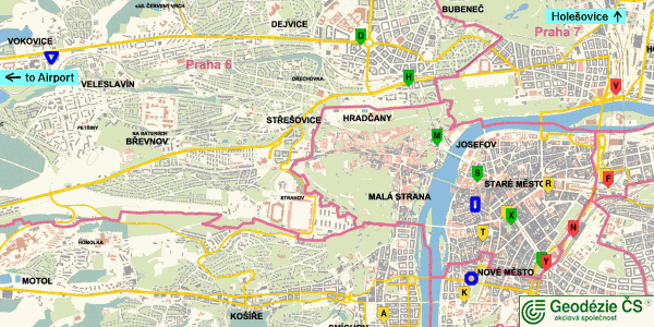
The small blue circle is the location of Department of Computer Science and Engineering, CTU Prague. The letters stand for the following Metro stations:
| Line A | Line B | Line C | |||||
|---|---|---|---|---|---|---|---|
| D | Dejvicka | A | Andel | Y | Muzeum | ||
| H | Hradcanska | K | Karlovo namesti | N | Hlavni nadrazi | ||
| M | Malostranska | T | Narodni trida | F | Florenc | ||
| S | Staromestska | X | Mustek | V | Vltavska | ||
| X | Mustek | R | Namesti Republiky | ||||
| Y | Muzeum | F | Florenc | ||||
Prague Public Transport
Tickets
The public transport system in Prague includes buses, trams, underground and funicular. The same tickets are used for all of these kinds. Note, that the tickets are not sold in the vehicles! This means you have to buy the ticket before - they are sold in news-stalls and in ticket machines. After entering any vehicle, you have to stamp the ticket in the stamp machine. Without stamping is the ticket invalid!There are two basic types of tickets: change and no-change. The change ticket may be used for either 60 or 90 minutes (see the table) after it was stamped and you can change as many times as you want during that time. Stamp your change ticket in the first vehicle only. The no-change ticket is valid for 15 minutes only and you cannot change.
| Change Ticket | No-change Ticket | |
|---|---|---|
| Week days 5:00-20:00 | 60 minutes | 15 minutes |
| Week days 20:00-5:00
Saturday, Sunday, holidays |
90 minutes | 15 minutes |
| Underground System (Metro) | 60/90 minutes | at most 4 stops |
The following picture shows the most common types of tickets. Note that the red word "<<VZOR>>" means "sample" and it is not present on the actual tickets.
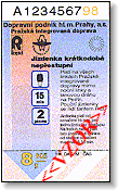
No-change ticket (8 CZK) |
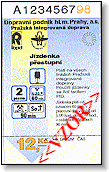
Change ticket (12 CZK) |
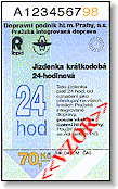
24 hours ticket (70 CZK) |
Prices
These are the actual ticket prices in August, 2002. I cannot guarantee the prices to you because they can change in the future.| Ticket | Price |
|---|---|
| Change Tariff | 12 CZK |
| No-change Tariff | 8 CZK |
| 24 Hours Ticket | 70 CZK |
| Three Days Ticket | 200 CZK |
| Seven Days Ticket | 250 CZK |
Metro (Prague Underground System)
The underground system consists of three lines: A (green color), B (yellow) and C (red). There are change stations between any two of these lines - Mustek (A and B), Muzeum (A and C), Florenc (B and C). The most important stations can be seen in the above picture.The main parts (including all change stations) of Prague undeground system was flooded during Agust 2002, so near all stations are out of order.
Now, undeground works in small number of stations in border parts of Prague only. There were created alternate lines X-A, X-B and X-C, which compensate the closed parts of undegroud lines A, B and C.
You can see actual public transport city map.